

At the Improvement Service, we promote and support the development of digital planning in Scotland. We want to see digital tools that make planning simpler, and meet the needs of planners, applicants, and communities across Scotland.
We provide digital solutions, services, and tools to support local planning authorities with digital and data. This includes delivering training, guidance, data, and visualisation tools to increase engagement with planning data.
Our information products are shared below.

How to map a 20-minute neighbourhood: data and methods
This technical note provides step-by-step guidance on how to conduct a 20-minute neighbourhood network analysis using ArcGIS Pro.
The analysis focuses on creating service areas around facilities commonly used in daily life and combining these service areas to assess the density of services within a given area. The final output is a map that highlights areas with varying levels of access to essential services within a 10-minute walking distance.
This package also includes ArcPy Scripts that you can use in your analysis.
Download 'How to map a 20-minute neighbourhood: data and methods'
If you are a local authority who would like support on implementing 20-minute neighbourhood analysis, please reach out via the email at the bottom of the page.

Housing Land Audit Interactive Dashboards
To support local authorities in visualising their housing land data, we have produced a suite of HLA dashboards.
These serve as a way to interrogate housing land within a planning authority. This service is open to any authority who would like an HLA dashboard.

Vacant and Derelict Land Dashboard
The Scottish Vacant and Derelict Land Survey (SVDLS) is a national data collection undertaken to establish the extent and state of vacant and derelict land in Scotland. The most recent dataset is from 2024.
The Scottish Government Communities Analysis Division produce a National Statistics statistical publication based on data collected and processed from all Local Authorities and Loch Lomond and Trossachs National Park Authority.
The Improvement Service then combine the site schedule produced by Scottish Government with spatial data showing the site locations. For more information, please visit the Improvement Service Spatial Hub.
The mapped sites show planning application information as of March 2026, where a planning application has been submitted within the site boundary. This data is drawn directly from local authorities and does not form part of the Scottish Government vacant and derelict land statistical return or the Scottish Government Planning Applications statistical return. These statistics may be found on the Scottish Government Planning Statistics website Planning statistics - gov.scot. These data have been quality assured by the Scottish Government.
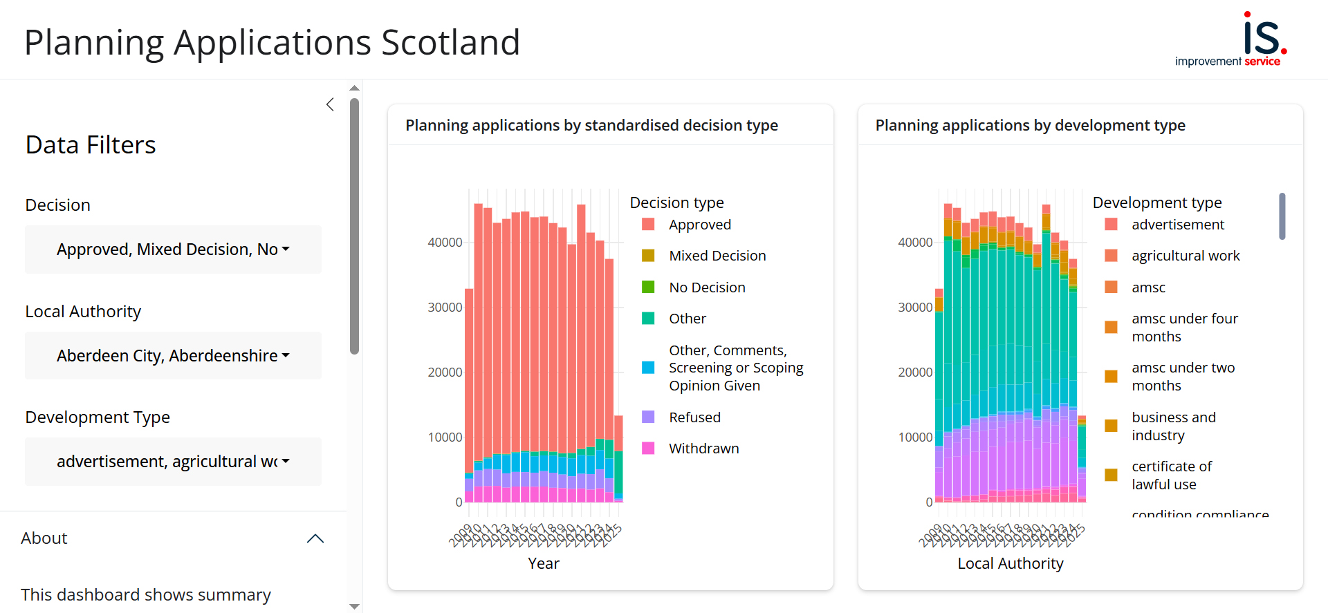
National Planning Application Dashboard
The Improvement Service remains committed in its mission to improve and enhance data for use across the public and private sectors in Scotland, championing Digital Planning. Supporting this goal, the Improvement Service is excited to unveil their new interactive planning application dashboard.
This tool enables members of the public, councillors, and businesses to explore trends in planning applications submitted across Scotland from 2009 to 2025. By standardising the underlying data, the Improvement Service has created a resource that allows for meaningful comparisons between different planning authorities.
Digital Planning Case Studies
Harnessing automation in planning: Highland Council housing completions dashboard
In the early 2000s, Highland Council’s research team developed a database to track housing completions within the council area. This work has evolved to support an interactive completions dashboard and map, which now forms the backbone of several reporting products.
Democratising access to information: Falkirk Council Open Spatial Data
Falkirk Council has recently launched a new Spatial Data Portal, marking a significant step forward in digital transformation and public engagement. This portal empowers residents, businesses, and stakeholders by providing easy access to a wide range of spatial datasets and interactive maps relevant to the local council area.